
|
According to The Commonwealth of The Bahamas, when Christopher Columbus had his maiden voyage in 1492, he landed in The Bahamas. Columbus and his men took the native Lucayans to work as slaves in the gold mines for Spain. The harsh conditions of the mines and the tough work the Lucayans did as slaves made them all perish before 25 years (History). According to Harper, the name of The Bahamas comes form the Spanish word "baja mar" meaning low sea or low tide (Online Etymology Dictionary). The World Atlas tells us that in 1717 the British invaded The Bahamas and made it a British Colony. The slaves in the country were emancipated from slavery in 1834 giving the country a new population increase (GEOGRAPHY). Info Please says the country became independent from the British crown on July 10, 1973 (Geography).
|
|
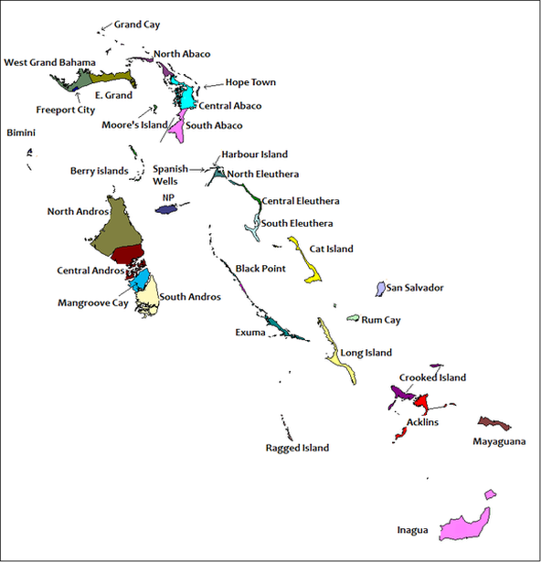
The country is split into 16 main regions as shown in the picture to the right. The Grand Bahamas is the northern most region and includes the island of Grand Bahama which is split into West and East Grand Bahama. Next is the Abacos region. This region consists of the islands of Great Abacos and Little Abacos. The Bimini region of The Bahamas includes North and South Bimini. This region is the closest region to the United States mainland. The Berry Island region is the next in the list. The Berry Islands consists of the Berry islands. Next the Andros region which consists of North, Central, and South Andros as well as Mangroove Cay. The NP region only consists of the island of NP. The Eleuthera region is created by North, Central, and South Eleuthera as well as the Spanish Wells and Harbor island. The Black Point region consists of Exuma island and Cat Island. The next six regions consist of only their one island. These regions are as follows: Rum Cay, San Salvador, Long Island, Ragged Island, Mayaguana, and Inagua. The final region is the Crooked Island region which consists of Acklins and the Crooked island.
|
|
